NASA Unveils the Most Detailed 3D Map of Mars
The most detailed interactive map of Mars has a resolution of about 25 square meters per pixel and was created by the scientists of the Bruce Murray Planetary Visualization Laboratory of the California Institute of Technology over the course of six years.

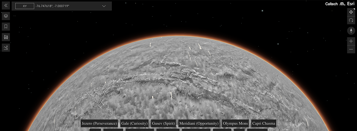
The Bruce Murray Laboratory for Planetary Visualization at the California Institute of Technology has created an interactive three-dimensional map of Mars that is now freely available to everyone.
The map was created by merging 110,000 images taken by the camera of NASA's Mars Reconnaissance Orbiter (MRO) and covers 99.5% of the planet's surface.
Both scientists and the public can navigate a new global map of Mars that shows cliffs, craters, and dust devil tracks in mesmerizing detail. It uses a mosaic composed of 110,000 images from NASA’s Mars Reconnaissance Orbiter. See more and try it yourself: https://t.co/TO69fe9pBK pic.twitter.com/4Dq0KnsVum
— NASA Mars (@NASAMars) April 5, 2023
The images were stitched together primarily by software, but scientists manually pieced together the remaining 13,000 images that the tech couldn't match. Scientists have been working on the map for over 6 years.
This is the most detailed map of the Red Planet to date, with a resolution of about 25 square meters per pixel. The mosaic image consists of more than 5.7 trillion pixels. The map allows you to explore the Martian surface, including its ancient river channels, impact craters, and dust devil tracks in great detail.
In addition, at the bottom of the screen, there are buttons that allow you to quickly find popular locations such as Jezero Crater and Gale Crater, which are being explored by NASA's Perseverance and Curiosity rovers.
The beta version of the map has already been cited by the authors of more than 120 peer-reviewed scientific papers devoted to the study of Mars.